BOXES 118-119: Out West: Arizona: Painted Desert to Canyon de Chelly.
- Joe Milicia
- Jul 31, 2021
- 6 min read
Updated: Aug 15, 2021

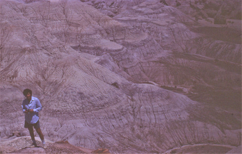
Look carefully at this photo and you'll see a person walking along a path. Look even closer and you'll see what could be a scattering of short logs in his vicinity. It's not exactly a forest, but there was one here once upon a time. We are in the Petrified Forest, the national park just over the border into Arizona from Gallup, New Mexico, where Max and I had spent the previous night. (See previous post on the powwow we attended there.)
Today's post covers three days in which we took a sort of clockwise loop through Arizona, from the Petrified Forest to some Frank Lloyd masterpieces in the Phoenix area, then Oak Creek Canyon, Meteor Crater, the Hopi Reservation and the Canyon de Chelly.
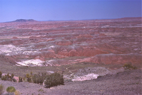
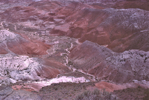
Our first stop after Gallup was actually the Painted Desert, the badlands extending northwestward from I-40 toward the Grand Canyon. This area is a vast expanse of wilderness, part of the Navaho Nation. Unless you're hiking or driving a vehicle suitable for off-roading, there's not much to do there except gaze at the empty but brilliantly colored spaces, as Max and I did:


A few wildflowers added bonus color:

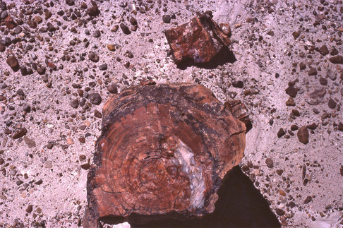
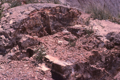
Petrified Forest National Park is mostly "across the street" on the south side of I-40, and inside the park a scenic drive took us southward with places to pull over to see the best remnants of logs turned to stone. (I won't attempt to explain the process here!) First I'll show some wider views, with logs scattered across the landscape, sometimes strikingly exposed through erosion. In a couple of shots Max provides perspective.


And here are some close-ups:


I like the following shot because it looks like we are looking up into cliffs, but in fact it's another close-up:

As in the nearby Painted Desert, occasional flowering plants added life and more color to the scene. Here are yuccas, Indian paintbrush, and a cactus flower:


After our morning among the petrified trees we headed southwest toward Phoenix, crossing the Mogollon Rim through pine forests, with the highway making a dramatic descent into the Phoenix area from the northeast. Our goal was to reach the Phoenix Airport that evening in time to pick up my UW-Sheboygan colleague Gloria Garvin, an anthropologist, who was flying in from her summer home with her family in Santa Monica to meet us for the continuation of our trip. We stayed overnight with Gloria's aunt in her house in Tempe, not far from the airport. I hadn't taken any photos since the Petrified Forest, but in the morning I did take this picture of the aunt's street, when I went for an early-morning walk, struck by the desert-landscaped front yards (and by the much greater heat than than anywhere previous on the trip):

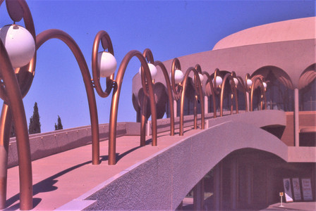
After leaving Gloria's aunt's, our first stop was close by, on the Arizona State University campus, for a look at one of Frank Lloyd Wright's last projects, Gammage Auditorium (completed 1964). In the first photo below you see Gloria and Max, backs toward us.


Our next stop was for more Wright: his winter home and studio, Taliesin West (1937), in Scottsdale. Along the way I took a couple of shots of the mountains that rise above the streets of Phoenix or Scottsdale:


Completed in 1937, Taliesin West was built pretty much surrounded by desert, and that was still mostly the case in 1978 when we visited. (Now, most of the vicinity is urbanized.)


But when I revisited Taliesin West just a few years ago, the house and grounds looked exactly the way they looked in 1978: i.e., as you see in my photos below from that first trip. Incidentally, it was an extra pleasure to be seeing Taliesin West because we had seen the older Taliesin, in Wisconsin, the first day of our trip.


Wright collected Chinese ceramics that he had mounted at various points on the grounds of the house, as you see in the above photo and in the following close-ups:


Also on view was an ironwork dragon:

And here is our tour guide :

Finally, here are a few interiors, starting with a couple of meeting spaces:


Lighting for many rooms, including the corridor below, was supplied or supplemented by canvas skylights (replaced by plexiglass for practical reasons even by 1978):

And finally, here are a couple of glimpses into the drafting studio on a working day:


From Taliesin West we headed north toward Oak Creek Canyon, which winds its way north to south from Flagstaff to Sedona, roughly speaking. Here are some shots of the rugged terrain on the way north from Phoenix, including a few saguaros in the first shot and a snowy mountain in the second:


But much more captivating than these views were the reddish colors and unusual shapes of Oak Creek Canyon:


We camped that night in Oak Creek Canyon. Here are two shots of the campsite, toward evening and then the next morning:


That evening we drove into Sedona, where there was a month-long movie festival showing films from the days when Oak Creek Canyon was a popular location for Hollywood Westerns. That night we saw the 1948 noirish Blood on the Moon with Robert Mitchum and a '30s B Western. Clearly there were locals, not just tourists, in the audience, since they laughed at certain moments where you'd have to be an insider to know what was so funny.
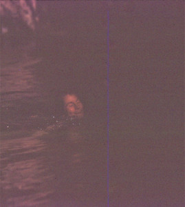
Our campsite was near Slide Rock, actually a natural water slide sculpted from a stretch of the sandstone bed of Oak Creek. We spent a lot of time there and at a deeper swimming hole farther downstream. I tried to get a couple of pictures of Gloria swimming and jumping off a ledge and into the pool; they turned out poorly (just a glimpse of legs in the second shot) but I'll include them here as part of the memory of the place:


To exit the head of the canyon on the north you have to drive up a series of switchbacks. Here are some views from the top:


Our next major goal was to visit the Hopi Reservation, of special interest to Gloria. Our route took us through Flagstaff and eastward along I-40. For a little while pine forests continued to dominate the landscape:

But soon we were back to desert country. We made a slight detour to see Meteor Crater --i.e., a meteor crater but one of the best preserved anywhere on Earth (the impact was only 50,000 years ago and erosion less than it would have been in a wetter climate). Here is a view of the crater from a distance, followed by two partial views from the rim. (If you'd like a better view of the whole crater, here is a professional panoramic view.)


Soon enough we left I-40 to head north to the Hopi Reservation. Our 2-lane highway went through expansive landscapes (part of the Navaho Nation, which surrounds the Hopi Reservation) where we saw very few cars or people. Occasionally the highway descended into a "wash" (gully) where signs warned us to watch for flash flooding. I've cropped most of the following photos to emphasize the land formations, but in one I've left more sky to give a sense of the vastness and emptiness of the drive.


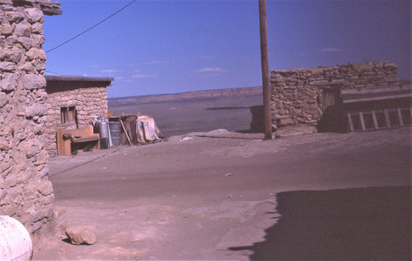
At the heart of the Hopi Reservation are three mesas topped with villages, one of which, Old Oraibi on Third Mesa, dates back to at least 1100. The mesas are not as high or inaccessible as the one for Acoma Pueblo. We were allowed to walk around the villages but not to take photos of people. Here are two pictures of one of the villages, followed by distant shots of (if I recall correctly) Old Oraibi, which is built onto a peninsula jutting out from Third Mesa.


The views from the mesas were ruggedly beautiful:

But the most thrilling landscapes (to us) were yet to come, as we headed northeast toward the Canyon de Chelly, back in the Navaho Nation. To drive through the canyon floor we would have had to hire a Navaho guide with a four-wheel drive vehicle (I don't remember if tours were being given at the time; probably advance reservation was needed), but we could freely follow the paved road upward from Chinle along the southern rim. The canyon grew increasingly deep and grand as we drove along it:


We had views of ancient pueblos built under rocky overhangs:


Here's Max leaping over a crack--probably less dangerous than it looks:

And here I am, sitting at the edge of the canyon, which is over 700 feet deep at this point. I have no idea how I was able to get myself to sit so close to the edge. I do recall that there were swallows whizzing about just below the ledge.

The most stunning moment was when we came to Spider Rock, rising 750 feet from the canyon floor.


Here are two more views, one of Spider Rock and the other of the road down on the canyon floor alongside the river:

And here are the road and Spider Rock together:

My last three pictures of the Canyon de Chelly may be fairly redundant, but I'll share them anyhow, if only to reemphasize how powerful an effect the place had on us:


I did take one close-up, of a cactus in bloom:

Our day continued as we drove to the Four Corners area and up to Mesa Verde National Park, where we camped that night. But since I've covered so much already in this post, I''ll save that for next time.
コメント